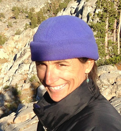
One of the first lessons I learned as a mom is that my kid decides who they are and what they like, not me. Damn.
So I can't really believe it as I watch them climb a granite block, high on a remote peak in the Sierra Nevada, up to my belay ledge. My heart soars. Since forever, I've dreamed of sharing mountaineering with them. Turns out, they're really good at it. But will they love it? They're 16 and have a life of options in front of them. We'll see. Right now, I’m just savoring the moment.
So I can't really believe it as I watch them climb a granite block, high on a remote peak in the Sierra Nevada, up to my belay ledge. My heart soars. Since forever, I've dreamed of sharing mountaineering with them. Turns out, they're really good at it. But will they love it? They're 16 and have a life of options in front of them. We'll see. Right now, I’m just savoring the moment.
 click any image to enlarge
 We had set out at from Glacier Lodge, on the South Fork trail of Big Pine Creek. Our packs were heavier than our usual Sierra summer backpacking trip… adding ropes, climbing rack, harnesses, climbing shoes, ice axes, crampons. My leg-strain gage said my pack’s about 45 lbs. Coby’s is heavier, but they accept the extra weight, shrugging.
Soon enough we rose into old growth whitebark, straining against the switchbacking trail. We settled in at Brainerd Lake to acclimate to elevation that night, then followed the trail from the west shore up to Finger Lake next day.
Soon enough we rose into old growth whitebark, straining against the switchbacking trail. We settled in at Brainerd Lake to acclimate to elevation that night, then followed the trail from the west shore up to Finger Lake next day.

From there, over a bean burrito dinner, we could see our first objective, Middle Palisade leaning back at the top of the glacier, a 14,000er with a moderate route perfect for intro to mountaineering, Clyde's class 3-4 Northeast Face. But from Finger Lake the route looked so steep. Class 3-4… really? My heart hammered, my sphincter tightened. I crossed my fingers and hoped the view was foreshortened.
I was discovering a new challenge - being a mountaineer and Mom simultaneously. Risk is very different with my kid in the picture. I cursed myself silently for being so nervous, while at the same time arguing with my husband about gear for the next day.
“We should bring a rope to protect Coby on the glacier approach. Maybe even on the climb. Yes to cams.” My husband finally realized that my new conservatism was as hard for me to accept as it was for him. He stopped arguing.
Next morning we left at dawn, with the mountain above us blazing golden in the first of the morning light. We contoured the talus heap hill and headed for the moraine that splits the Middle Pal glacier. Soon enough, we were strapping on crampons and trying to suss out the ‘easy’ diagonal ledges that supposedly led from the glacier to the route. The glacier was steep and still hard. We were glad for the crampons. I was glad for the rope on my kid.
There was no easy approach to this climb. Global warming has melted the glacier and the ‘easy’ ledge was well above us, accessible with a few fifth class moves on small, sloping ledges. But we made the ledge and traversed into the wide chute of the Northeast Face route. We gazed up.
There was no easy approach to this climb. Global warming has melted the glacier and the ‘easy’ ledge was well above us, accessible with a few fifth class moves on small, sloping ledges. But we made the ledge and traversed into the wide chute of the Northeast Face route. We gazed up.
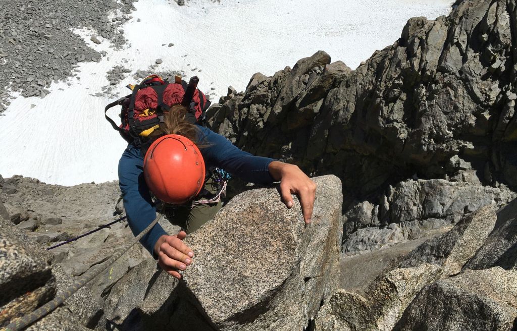
All that rock, it took my breath away… Gorgeous. Steep, yes, but not too steep. We simul-climbed on one rope, both up the chute and down, with Coby in the middle. Choosing to rope up meant we were inadvertently dragging rocks off ledges and inflicting them on ourselves. But no one else was in the chute with us, so the hassle (and danger) was ours alone.
The climbing was beautiful and easy, if exposed - a thousand feet of moderate rock chute like a giant’s slide. I was moving over rock, holding warm granite in my hands, reforging my relationship with the mountains. It used to be my life. Big mountains in Alaska. Ecuador. Nepal. And twenty years ago, on a month-long climbing trip here in the Sierra, my then-boyfriend and I decided to spend the rest of our lives together. There he was, above us, leading the climb. I breathed in that gunpowder scent of granite mixed with my own sweat. I hadn't been mountaineering in seventeen years.
I bit my lip. My new uncertainty and caution, was it for my kid... or was it for me?
Far below, we watched a group climb to the base, looking for access to the route, and then retreat. We downclimbed to the glacier by 2:30p. Back at Finger Lake, the team we saw from above told us they hadn’t brought a rope, and didn’t find an approach they were comfortable doing. I mused, knowing we almost didn't bring a rope, too.
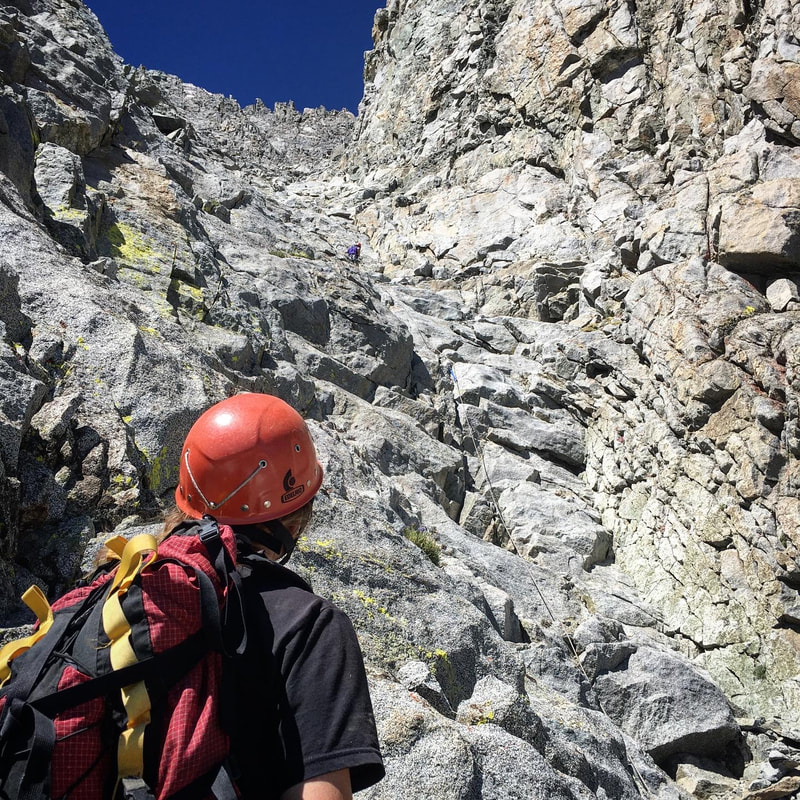
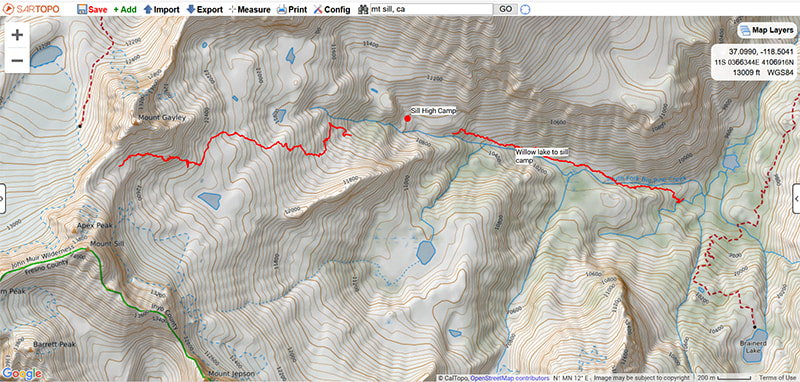
 Mt Sill high camp (click any image to enlarge)
 Our next objective was Mt Sill.
Charlie and I had pored over descriptions to the approach from the South Fork. ‘Endless talus’ and ‘sea of talus’ on one hand. On the other, Scaruffi said 'my favorite approach', ‘remote, no one else here’, ‘beautiful’.
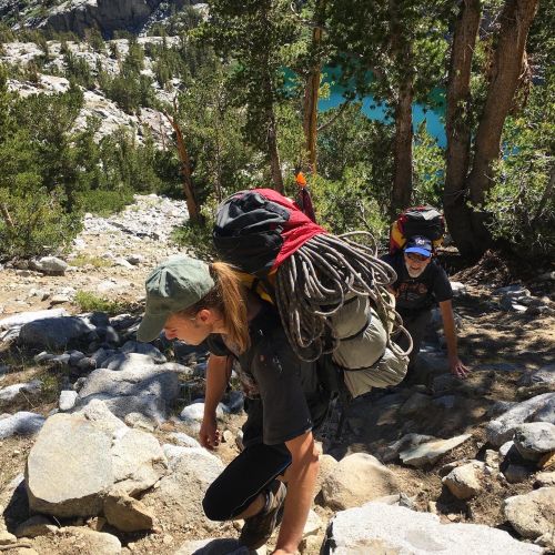
So, with question marks over our heads, we left the trail, crossed the stream, and headed up the western drainage of South Fork (see <GPX>). Immediately, we found a use-trail that hugged the south side of the stream, shaded by trees and well-maintained through chinquapin shrubs. It brought us to the described stream-crossing at the first tributary. The north side of the creek was talus, but well-cairned. Coby had a knack for finding the best route, hopping easily among the huge rocks with their heavy pack. They were an open heart, taking in everything, pointing out flowers, noticing the short-tailed weasel, smiling in talus. I tailed them closely, trying to match their pace and exuberance. And failing.
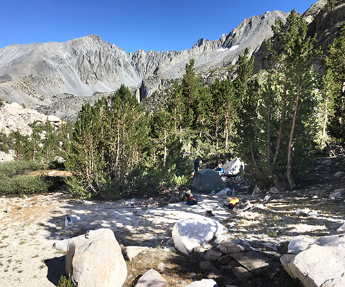
The intense sun drained us. We rested in the shade of a giant slab and dipped hats and bandanas in the stream to cool off. We found the team from Finger Lake also sheltering under a giant boulder and exchanged some good laughs. Exiting the talus, we followed a trail up loose sandy slopes. Finally, cairns traversed left through grass and flowers to a beautiful hanging valley – wooded on one side, the other a sandy slope. A crystalline stream wound between. A use-trail took us across the sand slope and up to a copse of pine with many flat sites for camping, little-used. UTM 11S 0368374E 4107335N (WGS84).
Charlie and I had pored over descriptions to the approach from the South Fork. ‘Endless talus’ and ‘sea of talus’ on one hand. On the other, Scaruffi said 'my favorite approach', ‘remote, no one else here’, ‘beautiful’.
So, with question marks over our heads, we left the trail, crossed the stream, and headed up the western drainage of South Fork (see <GPX>). Immediately, we found a use-trail that hugged the south side of the stream, shaded by trees and well-maintained through chinquapin shrubs. It brought us to the described stream-crossing at the first tributary. The north side of the creek was talus, but well-cairned. Coby had a knack for finding the best route, hopping easily among the huge rocks with their heavy pack. They were an open heart, taking in everything, pointing out flowers, noticing the short-tailed weasel, smiling in talus. I tailed them closely, trying to match their pace and exuberance. And failing.
The intense sun drained us. We rested in the shade of a giant slab and dipped hats and bandanas in the stream to cool off. We found the team from Finger Lake also sheltering under a giant boulder and exchanged some good laughs. Exiting the talus, we followed a trail up loose sandy slopes. Finally, cairns traversed left through grass and flowers to a beautiful hanging valley – wooded on one side, the other a sandy slope. A crystalline stream wound between. A use-trail took us across the sand slope and up to a copse of pine with many flat sites for camping, little-used. UTM 11S 0368374E 4107335N (WGS84).
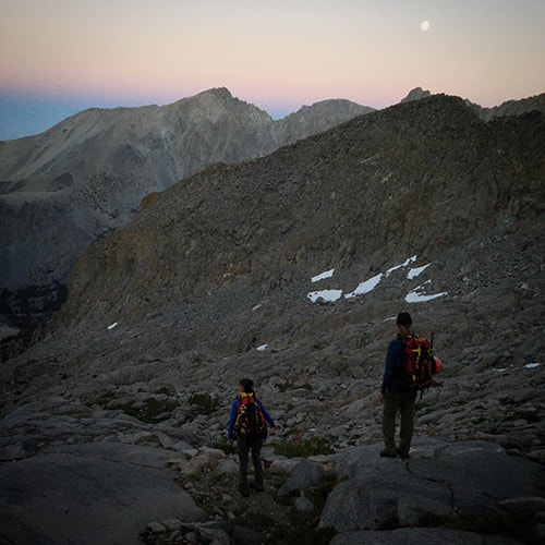
That night, the nearly-full moon hung low in the sky, making flat black silhouettes of conifers and the crenulated mountains, the same moon from seventeen years ago when I lived and breathed mountains. Yes, you're a mother, the moon whispered to me ... Yes you are a mountaineer. Yes, you are older. All those things give you strength. Don't doubt yourself.
We left camp at 6a. Cairns led us up the northern side of the creek to a broad flat marsh. We crossed this and, following Scaruffi's directions, climbed the dry, talus-choked gully far left of the waterfall. At the top of the gully, we headed straight toward Gayley over beautiful granite slab. We passed hidden streams everywhere and profusions of flowers. It was like hiking through a garden. We took turns route-finding - linking ledges and moving upward until we came to snow patches and moraine. At the high point at the base of Gayley, at the base of a cliff where you can see the saddle between Gayley and Sill, we found a way through the cliff on loose sandy ledges past an obvious finger on a Gayley buttress. From here we climbed over talus to the base of the L-shaped snowfield on Mt Sill <GPX>, arriving around 9a.
We left camp at 6a. Cairns led us up the northern side of the creek to a broad flat marsh. We crossed this and, following Scaruffi's directions, climbed the dry, talus-choked gully far left of the waterfall. At the top of the gully, we headed straight toward Gayley over beautiful granite slab. We passed hidden streams everywhere and profusions of flowers. It was like hiking through a garden. We took turns route-finding - linking ledges and moving upward until we came to snow patches and moraine. At the high point at the base of Gayley, at the base of a cliff where you can see the saddle between Gayley and Sill, we found a way through the cliff on loose sandy ledges past an obvious finger on a Gayley buttress. From here we climbed over talus to the base of the L-shaped snowfield on Mt Sill <GPX>, arriving around 9a.

I had planned to practice ice-axe arrest with Coby anyway on the lower snowfield. But as we watched two climbers high on the steep snowfield above us, one fell and careened down into the other, knocking them over. They both slid. Although one popped to their feet again, the other didn’t.
OK, I thought. This may not be a climbing day, it might be a rescue. I took a deep breath, reviewing my WFR training and considering systems for lowering an injured person down the snow. I cupped my hands and yelled, one word at a time, “DO. YOU. NEED. HELP?”
There was a pause. “NO. I. AM. OK.” Came the reply. Whew.
I had Coby practice ice-axe arrest seated, standing, and falling over backwards. Then we strapped into crampons and tied into our rope. I took the lead up the steep snowfield. As we passed the now-descending climbers, we got the chance to chat. They seemed fine and had made the decision to call it a day. They told us about the ice on the sides of the snowfield that had caused their fall.
Sure enough, when I tried to exit the snowfield for the 4th class ramp to the Swiss Arete, I hit a six-foot edge of blue ice. This climb has a little of everything. I smiled and planted my pick and kicked in my front points. Coby figured it out on their own and swung their axe and kicked in their front points as I belayed them and Charlie across.
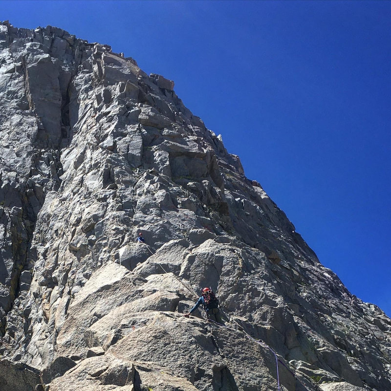
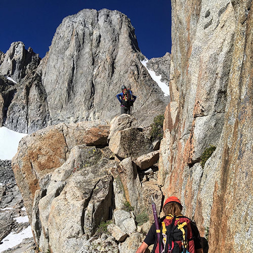
It was 11a before we gained the Swiss Arete, a perfect ledge in the perfect sun. Charlie led the hardest three pitches, including the airy traverse and 5.6 corner. Coby figured out soon enough that climbing with a pack isn’t easy. We’d brought our crampons, ice axes, and boots in two packs up the climb. Nor is being the middle person in a group of three, with a rope above and rope drag behind. But they did great. I, for one, was glad to ditch the pack to lead the final two easy pitches to the summit. We summited at 4p.
Finding our way down was straightforward, except for locating the rappel station. The down-climbing toward North Pal, then the Sill-Apex notch, is well-cairned, solid and not too exposed. The rappel was lower than we thought. We rappelled to a ledge behind the Sill-Apex notch. While it looks like you continue down over steep smooth slab to sand below the notch, go UP to broken rock to the right above the notch. From there, the descent to the notch was easy. We found a trail next to the snowfield and skipped about third the snow before we had to don our crampons again, cross the hard ice to the soft snow in the middle and downclimb easily to the base. We followed our GPX track (SARTopo app - thanks Matt!) back through the finger notch before the sun set.
Coby led most of the way back, recognizing boulders, ledges and flowers from the morning’s ascent. They’d point and, sure enough, there were our footprints. Mind-boggling, that sharp teenage brain...
The nearly-full moon lit up the white granite of our descent, shining our way back to camp without the need for a headlamp, like a promise fulfilled, like a memory from a past life.
We made it back to camp at 9p.
Family Trip, July 28-August 3, 2020. Middle Palisade, Northeast Face (class 3-4). Mt. Sill, Swiss Arete (5.6). Charlie Huizenga (Dad), Jeanne Panek (Mom), Coby Huizenga (16yo)
SLIDESHOW: